Mineral Feasibility Studies: Essential Guide for Mining Projects
A mineral feasibility study is a comprehensive evaluation of a mineral resource to determine if it can be mined profitably. It involves assessing various factors such as the size and quality of the mineral deposit, the technology required to extract it,…

What is a sand dam?
Sand dams are simple, low-cost, and effective structures built in arid and semi-arid regions to improve water availability by capturing and storing rainwater and sand. Here is a step-by-step guide to the construction of a sand dam: 1. Site Selection Community…

What is GeoAI?
GeoAI refers to the integration of artificial intelligence (AI) and machine learning (ML) with geographic information systems (GIS) and spatial data analysis. This combination enhances the ability to analyze, interpret, and visualize geographic data for various applications. Here are the key…
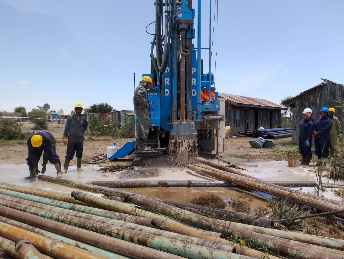
Boreholes: Enhancing Farming in Kenya
Boreholes represent a crucial aspect of modern farming techniques, particularly in regions like Kenya, where access to water can be a limiting factor in agricultural productivity. Essentially, a borehole is a narrow shaft drilled into the ground to extract water. In…

What are GeoTools?
Geotools is widely recognized for its flexibility and extensive support for different data formats, making it suitable for a diverse range of geospatial applications. Developers often appreciate its modular architecture, which allows them to select and use only the components necessary…

Solarization Bags
One intriguing application of solarization is found in the use of solarization bags. These bags harness solar energy for specific purposes, creating a sustainable and efficient solution. However, like any technology, solarization bags come with their own set of advantages and…
What is solarization?
Solarization, a term encompassing various fields, holds immense significance in today’s world. From agriculture to art, understanding the diverse aspects of solarization is crucial for harnessing its benefits effectively. Solarization Meaning In its simplest form, solarization refers to the process of…
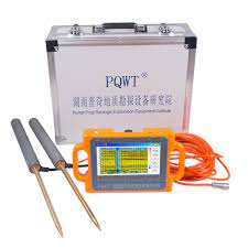
How to use PQWT in survey?
Using a PQWT (Portable Quick Well Tester) in the field involves several steps to conduct groundwater exploration and determine the depth and yield of water wells. Here’s a general guide on how to use a PQWT in the field: Preparation: Familiarize…

How to use a terrameter SAS1000
Using a terrameter involves several steps to ensure accurate measurement of subsurface resistivity for geological and geophysical investigations. Here’s a general guide on how to use a terrameter: Preparation: Familiarize yourself with the terrameter’s components, including the main unit, electrodes, cables,…
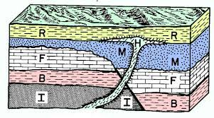
Exploring the Depths of Structural Geology
Structural geology is a branch of geology that deals with the study of the architecture, deformation, and tectonic processes of the Earth’s crust. It focuses on understanding the formation and distribution of geological structures and their implications for Earth’s evolution and…